The genealogy land patent maps housed on the US Government’s General Land Office (GLO) can be searched using several interactive tools. Using these tools, I will show you how to find land records, deeds, surveys, and attach them to your Ancestry tree.
This post is a follow up to the introductory US Genealogy Land Patents: How To Use GLO Land Records article, which provides the framework for this deeper dive.
 AI Trust badge. This post is 100% human content.
All words were generated by Franklin, the founder and Source Hound.
Table of Contents
GLO Land Patent Maps Search Area
Let’s dive into the Source Hound methodology to use the GLO land patent maps so that you find the most records and understand the tools they have available, because they are not super obvious at first glance.
The Genealogy Land Patent Maps TOOLS I will cover:
- The Search bar
- The “Search In” drop down menu
- The Information tool and “Question Mark”
- The floating dock
- The Maps Print, Legend, Layers, and “Basemaps” menu
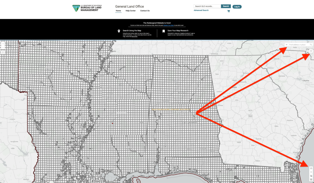
While the map feature itself may remind you of a Google Maps-type deal, behind every state and county lies clickable land patent records. The trick is knowing how to use the tools properly to get at them.
The Map Search tool and the Advanced Search bar at the very top of the site are more or less complimentary; however, the advantage of using the maps to search is that you know exactly what you are looking at, with records you may not!
If you’re ready to follow along, visit the General Land Office (GLO) website.
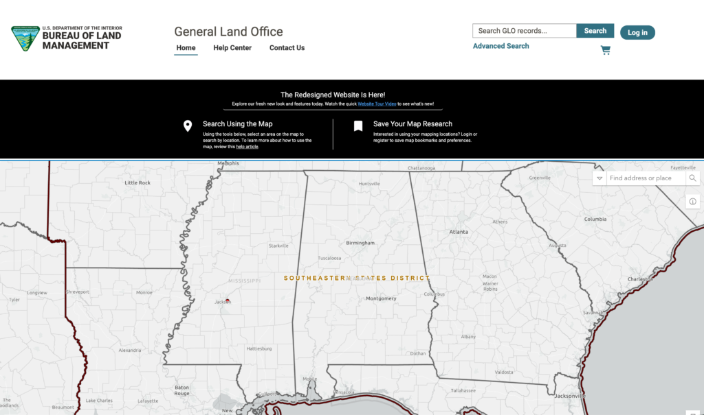
GLO Land Patent Maps Search Bar
Let’s dive into our first tool, the Search bar. This is no ordinary search bar! This is a geolocation search bar which allows you to instantly zoom into any town, county, or area on the map. This is super crucial because as you zoom in on the GLO land patent maps database, the more confusing it is to make sense of where you are.
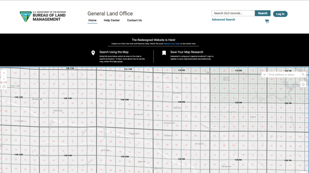
Can you make sense of where things are on this map? Unless you are very familiar with your genealogy research, it’s hard for the average person to make sense of this. Hence why I recommend using the search bar!
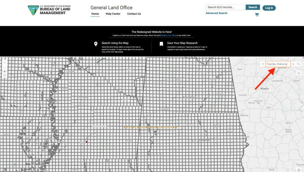
The map search bar is located at the top-right of the map area. If you type in the city or town of your ancestor coinciding with your research, the map will auto zoom you right into that GLO township and range.
FRANKLIN'S STORY
In the example below, I searched for the tiny town of Townley, Alabama. This is where I visited to research my Walker County, Alabama roots. I documented our family cemetery here and did research using this site. I even found the long-lost ghost town of my 4th great-grandfather!
GLO Land Patent Maps “Search In” Drop Down Menu
Another tool alongside the map search bar is the “Search In” drop down menu. This gives you the option of searching within specific databases: Geocoder, Legal Land Descriptions, and Serial Number.
My suggestion is to leave it on the default “All” setting.
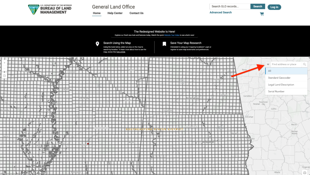
Come back here and refine your search once you are more familiar with this site and how it operates. If this is the first time you are using this GLO land patent maps site, leave the default setting as is.
There’s much more to explore with the “Info” and Question Mark tool! That’s up next!
GLO Land Patent Maps “Info” Tool and “Question Mark”
Now that you have searched using the search bar and are focused in on a specific meridian, range, or township, let’s use the INFO TOOL and the floating QUESTION MARK.
Once you are zoomed in (or not), click on the INFO tool shown in the image below. This will turn your cursor into a FLOATING QUESTION MARK. Use that question mark to click on any area and it will highlight itself!
You are on your way to finding genealogy land patent maps, “yessiree!”
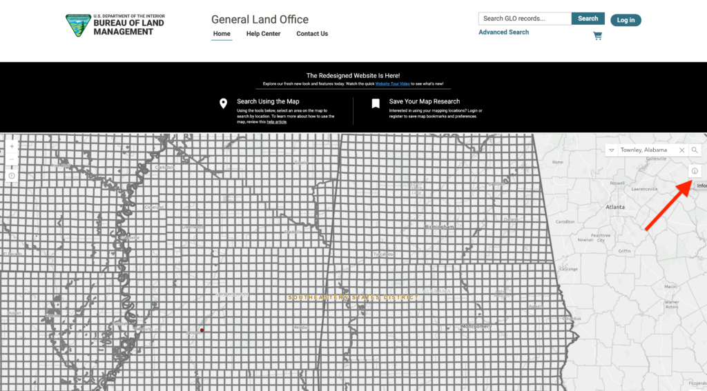
Once your map plat has been highlighted, a floating dock will appear! The purpose of the Info tool is to highlight your focused area and give you access to land records via the dock.
Not to sound corny, but this IS where the magic happens! Let’s jump on that dock next.
GLO Land Patent Maps Floating Dock
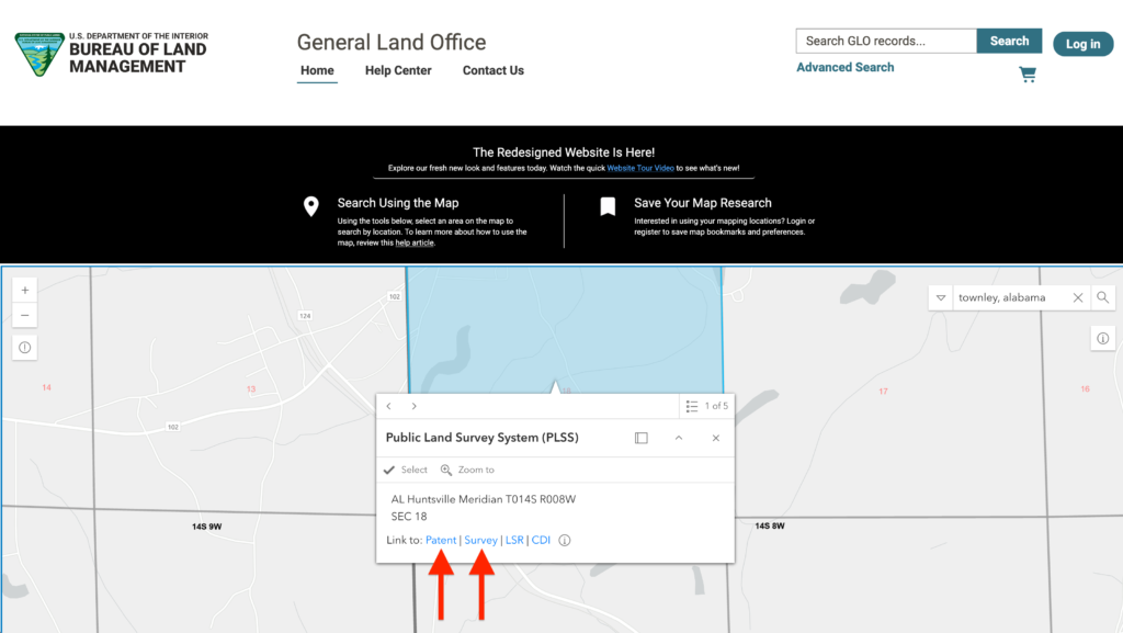
Down in the bottom-left corner is a floating Public Land Survey System (PLSS) information tool which links you to the records database. What we want to do next is unlock the dock from its sticky position and expand it out so that you can actually use it.
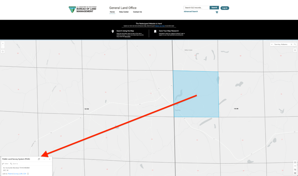
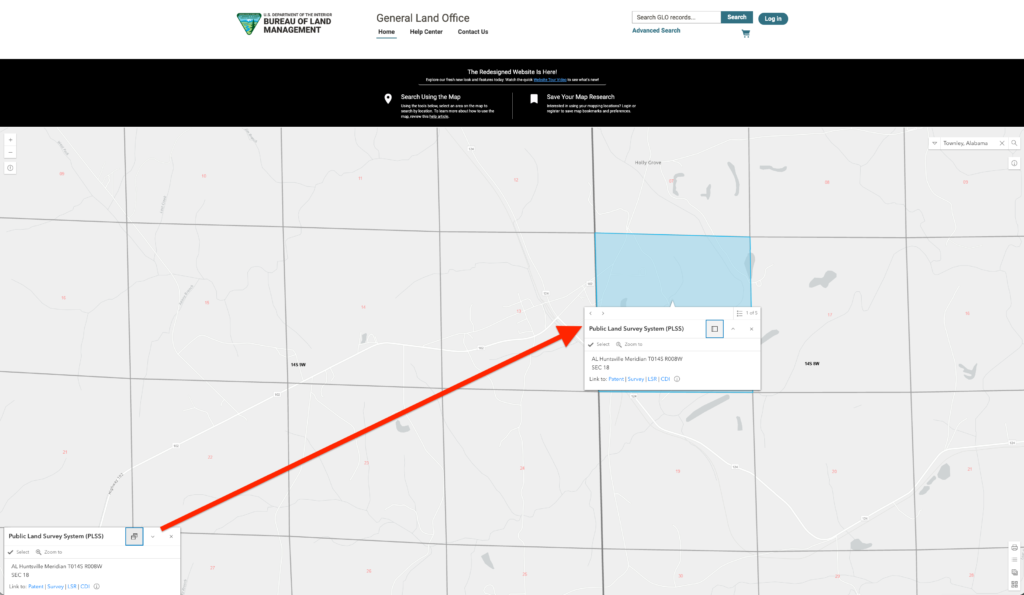
You will do this by clicking on the two boxes on the top of the floating dock menu and it will “undock” itself. It will then attach itself to your highlighted search area.
Actually, a new dock will appear beneath the area you highlighted with the Info tool. This makes is much more usable as it sits right beneath, attached to, your search field. You can refine this search field by using the tools on this dock.
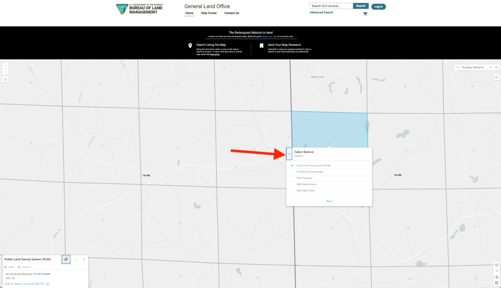
For example, if you expand out the top-left portion of the dock (shown below) it gives you the ability to automatically focus out to broader map zones. They zones get larger as the selections go down the menu.
Try it for yourself and see what happens! You can always select the top level if you get lost.
The most important feature of this floating dock are the PATENT and SURVEY buttons! For any field you are searching, you can instantly click on either PATENT or SURVEY and the GLO maps tool will head you straight over to the records corresponding to that specific plat.
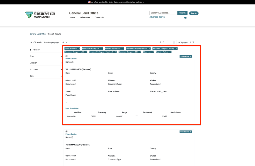
Be careful using this route to find genealogical information. When you click on PATENT, for example, the records page will return every single patent for this quadrant!
When I searched for the plat above, I got almost 400 records. Those were not records attached to my family, necessarily, I still had to sort and sift through them to find my ancestors’ surnames.
Read the preceding article to learn how to use the Advanced Search on the BLM GLO website to find specific records.
GLO Land Patent Maps Print, Legend, Layers, and “Basemaps” Tools
Now that you know how to find land patent maps records within the GLO database using the maps search, let’s talk about how to refine that search by using the additional tools buried on the bottom of the maps page.
Can you find it? It’s a teeny, tiny tool hiding at the bottom-right of the page! Often times it is not even showing, but I’ll tell you how to fix that too.
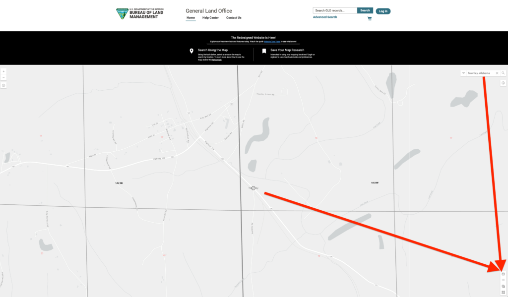
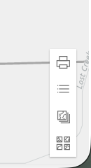
I have to really zoom in to show you what this menu is and the 4 tools it contains. The 4 tools, from top to bottom, are: Print, Legend, Layers, and “Basemaps.”
It’s strangely ironic that this “hard to find” tool just happened to be right next to “Lost Creek” on my screenshot. That’s wonderfully poetic.
The GLO Map Print Tool
The Print feature is pretty obvious, it let’s you print the page in various formats, including PDF. You can use this to build out your Ancestry tree, more on that in the last section.
The GLO Legend Tool
The Legend feature allows you to read the multitude of map legends. While this may seem superfluous, it’s not if you are wanting to get granular in your research.
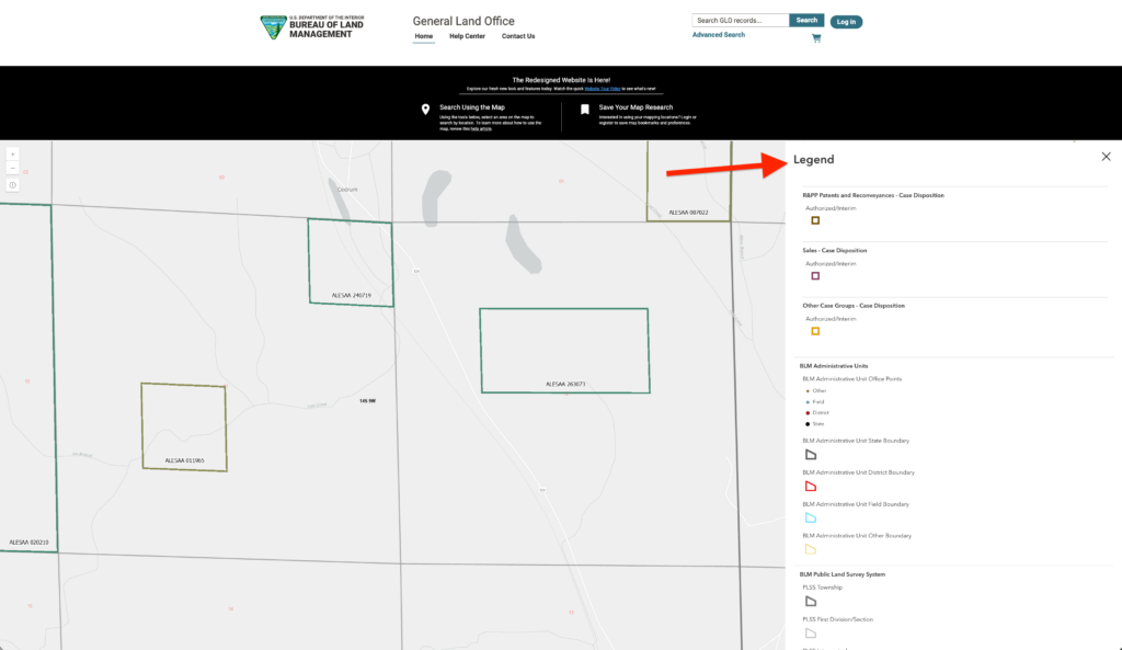
This image is showing you the basic map legends to help decipher features shown on the map. You can actually scroll down within this legend window, there’s A LOT more there which is not shown. This may or may not be helpful in your land patent search; however, it is good to know it exists.
Actually, what you see in the LEGEND expands based on how you use the next tool!
The GLO Layers Tool
The Layers tool feature is the most intriguing to me as a genealogist. When you click on it, it reveals a HUGE menu of options, of LAYERS!
These go DEEP. If you notice, each of the items on the menu can be expanded, and many of the subcategories can be expanded even further. That’s an incredible amount of detail!
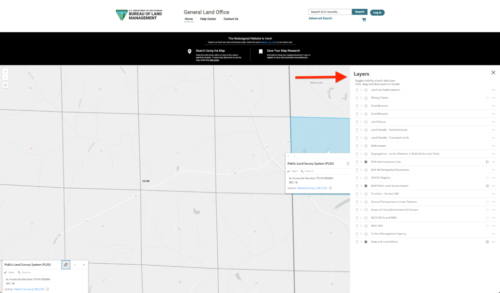
In the example below, I’ve expanded out the Land Surveys category to reveal 5 subcategories, the last one of which I expanded out to reveal 3 more! The grid icons to the left indicate that you can reorder these by dragging and dropping them.
Oh boy, all that hiding out in the corner!
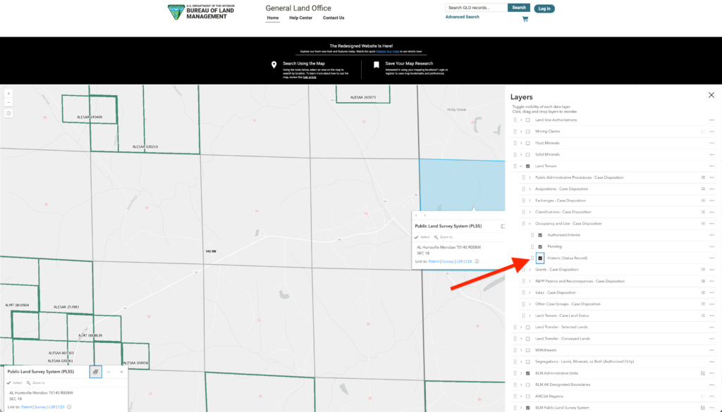
Each time you click on a box within this Legend, new information shows up on the map. As I selected boxes on the legend, the green lines appeared within the plat boundaries within this range of Walker County, Alabama.
You should definitely take time to learn this tool and see if it will impact your genealogy research.
The GLO Basemap Tool
The last tool or feature on this menu is called “Basemaps.” This tool does not link you to any land plat records, it helps you to see more details on the maps themselves. It is also a great genealogy tool, read on to find out how.
When you select the Basemap tool, it will open up an options box. This box is scrollable! There are 38 options total!
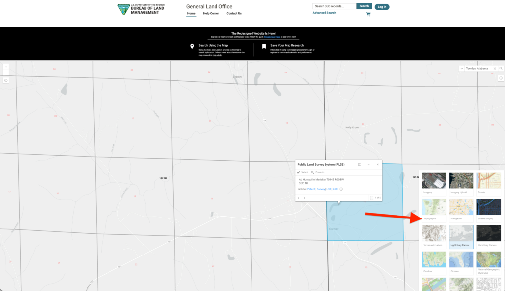
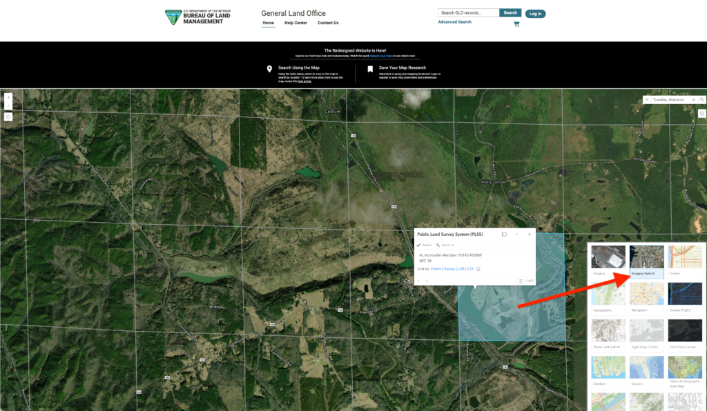
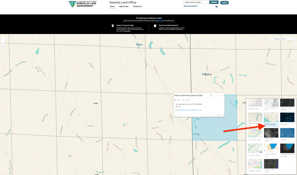
If I select the Topographic or Imagery Hybrid option, the display will change. Instead of looking at a bland, featureless map, you get to see a sattelite-ish view. Now that is useful!
FRANKLIN'S STORY
I used maps like these to document my 4th great-grandfather's long-lost ghost town! In 1879, after the Civil War, my ancestor founded his own town which is now on the official registry of US ghost towns. I decided I would find it, so I went on a family history road trip and the only way I actually could geolocate his property from nearly 150 years ago, was to use GLO maps!
Again, if you scroll down, there are a total of 38 different map options to choose from.
I believe we can learn a great deal from “reading the land” as a Source Hound genealogy technique. Look at the natural features relative to a town or family dwelling.
People always needed water. Where are the streams? Is it mountainous? How would you envision building a residence with in the topography? Where are the farms? These are all questions you should be asking as you look at these maps.
Choose the map which helps you bring these features to light! Use them as a research tool.
Land Patent Maps Tricks and Hidden Features
The one “trick” I can offer is in regards to the Print, Legend, Layers, and “Basemaps” Tools Menu just discussed. It’s “hidden” by the fact that this tool isn’t always visible!
If your browser is ZOOMED IN to make your font more readable, then this menu disappears and you may only see the top tool on the menu. If you are on the GLO site and cannot see these tools on the bottom-right of your page, simply ZOOM OUT.
It’s important to use this tool and familiarize yourself with its capabilities. Don’t lose out because you didn’t even know it was there.
Using GLO Land Patent Maps on Ancestry
Quick Source Hound lesson. The final step for your family history research journey on the GLO Genealogy Land Patent Maps site is to export these records and attach them to your Ancestry.com page, or other genealogy platform.
I’ve covered many ways to accomplish this, so begin with printing the record to a PDF and saving it to a research folder. You can then upload this to Ancestry. I’ll use Ancestry as an example, you can apply it to FamilySearch or any other platform.
QUESTION: what is more important than the genealogy record?
ANSWER: how you document it!
None of these GLO records mean anything if you do not adequately label and document WHAT the information is and WHERE it came from. When you are adding these resources to Ancestry, always include as much information as possible from the search return.
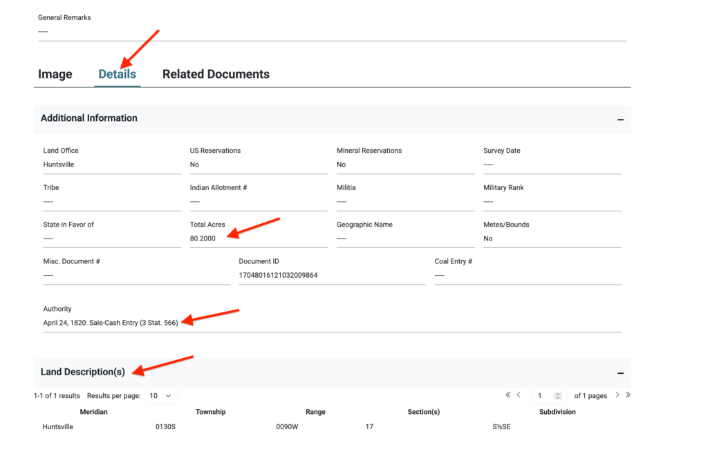
I would even suggest screenshotting a records page like this IN ADDITION to indexing the record with the Meridian, Township, Range, Section, Subdivision, Acres, Document ID, etc.
You should also link this to the DEED which comes with any GLO record.
You should also include the URL to the GLO website page from where the information came (just copy and paste whatever is in the browser’s web address for that page). You should do this as a matter of course so that you can find it easily in the future.
Don’t shrug your shoulders, just do it.
This takes time to add a new record on your ancestor’s profile page, but it is well worth it. You can then add it into your ancestor’s timeline!
TOP TIP: In addition to simply downloading an image, do what I’ve repeatedly done: draw on them! Keep an original copy (the GLO site always has the original copy) and then draw arrows or boxes or write notes on the image to help you identify what is going on and the most pertinent information.
That’s your quick Source Hound lesson for this post! Watch the video episode of this post on YouTube and make sure to subscribe to my channel and sign up for my Newsletter below. Cheers!
Join the Family History Foundation Source Hound Community
Our family history is disappearing every day, join the Source Hound community and join our pledge to be the protector of your family history. The lives and voices of our ancestors are depending on it for our future generations.
Celebrate Family History Fridays with us across our social media and community platforms!
📬 Subscribe to the Newsletter — tips, active challenges, and deep-dive case studies. Never an overloaded inbox, always something you can use this weekend.
 Like & Subscribe on YouTube — every Friday, a video companion to the week’s article. Watch these techniques demonstrated rather than described.
 Pin Us on Pinterest — printable question sheets, research charts, and visual guides to save for your next session.
 Podcasting on Spotify! — podcasting now on Spotify, you can find all of the latest episodes on any of your favourite podcast platforms, starting with Spotify.
 Podcasting on Amazon! — If you are not on Spotify we are also on Amazon Podcasts so you can listen while you drive and work. Every episode is curated just for you to binge your favourite episodes.
 Podcasting on Audible! — Audible is an alternative offshoot of Amazon Podcasts to listen while search for your next favourite book. Ready for your next “audible?” Set, Go!
Let’s make Family History a household word. 🏠

The Family History Foundation Newsletter
Our Family History Is Disappearing Every Day!
Join the quest with 500+ family historians getting Franklin’s Source Hound weekly research breakthroughs — real case studies, source hacks, and the exact strategies that turn brick walls into discoveries.
Free. No fluff. Straight from the Source Hound’s desk to yours.
Your privacy is sacred — almost as sacred as a primary source. Read our Privacy Policy.
Shop Premium Genealogy Forms
About the Author
Hi there, my name is Franklin, the founder and author of The Family History Foundation.
Our family stories are disappearing every day and it’s crucially important that the next generation is able to learn and appreciate their family history. It is up to you to take up the mantle of responsibility to ensure that how you research today will be passed on tomorrow with the highest standards possible.
I believe that genealogy is not just about names and dates, it’s about your stories and how those stories inform your identity.
With a penchant for storytelling and a background in research, the insights and techniques you learn on The Family History Foundation will help you uncover the incredible stories and identities hidden within the tapestry of your ancestry.
My mission is “Let’s make Family History a household word.”
My motto is “The Past ‘Relative’ to the Future.”
FAQs
-
Q: How do I search for a specific location using the GLO map search bar?

A: Type an address, city, county, latitude/longitude, or PLSS legal land description into the top search bar and press Enter to auto-zoom to that location.
-
Q: What options are in the GLO map “Search In” dropdown menu?
A: The dropdown offers three search modes: Standard Geocoder (addresses, cities, coordinates), Legal Land Description (Township, Range, Section), and Serial Number (BLM document file numbers).
-
Q: How do I view land patents for a specific spot using “The Dock”?
A: Click the “i” (information) icon in the top-right toolbar, then click any map parcel. “The Dock” window in the bottom-left corner will display direct links to all land patents, survey plats, and tract books for that location.
-
Q: Which GLO basemap is best for genealogy research?
A: Use Aerial/Satellite imagery to see modern land use over historical boundaries, USGS Topographic to view physical terrain and rivers, or Streets/Hybrid to navigate to the plot using modern roads.
-
Q: Can I search for land patents in non-PLSS states on the GLO map?
A: No. Selecting non-PLSS states (such as the original 13 colonies or Texas) displays an info card identifying the responsible state archive or BLM administrative office rather than individual land parcels.
-
Q: How do I save or print a copy of my ancestor’s property map?
A: Click the Print icon in the map toolbar, select your desired title, page orientation, and file format (like PDF), then click Print to open a formatted map in a new browser tab.